Mapping with geopandas and basemapping with contextily
I find the geopandas library to be really useful for mapping with layers.
Contextily is also a nice library that allows adding a background basemap.
Using them together makes it fairly simple to visualize shapes such as polygons and points, together with contextual mapping information, such as in the following figure:
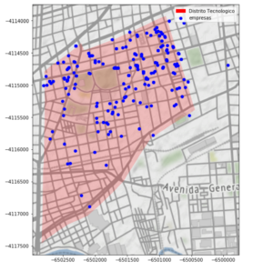 Basemaps are drawn from OpenStreetMap under CC BY SA and map tiles are from Stamen Design, under CC BY 3.0. There are some options for tile design.
https://gist.github.com/rpasquini/395ecc6e5fafb1b6da2395f174dbda14
If embedded notebook does not render try here
Basemaps are drawn from OpenStreetMap under CC BY SA and map tiles are from Stamen Design, under CC BY 3.0. There are some options for tile design.
https://gist.github.com/rpasquini/395ecc6e5fafb1b6da2395f174dbda14
If embedded notebook does not render try here